Tropical Storm Imelda Update: Rain Expected for North Carolina
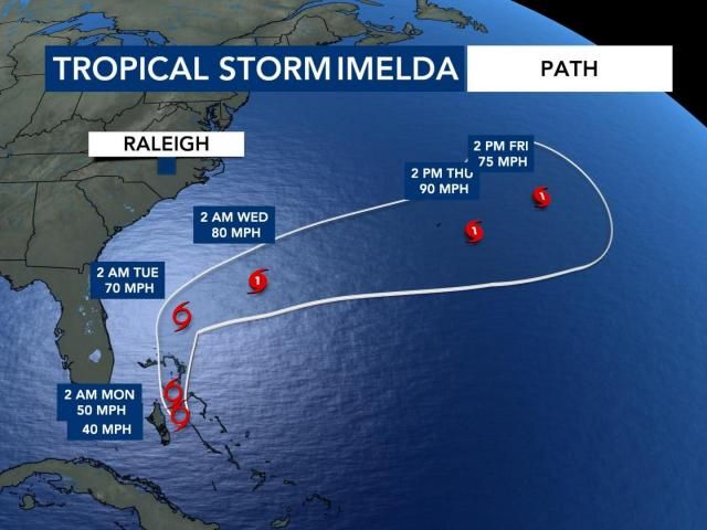
WRAL meteorologists are tracking Tropical Storm Imelda, which formed Sunday afternoon, along with its interaction with Hurricane Humberto far off the coast. Imelda is forecast to bring waves of rain to North Carolina, mainly on Monday and Tuesday, which could lead to localized flooding. This tropical system will primarily be a rain event, with winds not a major concern.
Latest Updates
8 p.m.: Tropical Storm Imelda is still forecast to make a turn to the east-northeast on Tuesday and stay well off the North Carolina coast. There will be high rip current risks Monday through mid-to-late week, along with rough surf offshore.
5 p.m.: Tropical Storm Imelda continues to move with maximum sustained winds of 40 mph. The storm remains on track to bring tropical storm conditions to the Bahamas before dropping rain on the Carolinas Monday and Tuesday. It is also possible that Hurricane Humberto, a Category 4 storm, could pull Imelda away from the coast.
2 p.m.: Tropical Storm Imelda formed with maximum sustained winds of 40 mph. The storm is expected to bring tropical storm conditions to the Bahamas and move north, delivering heavy rain to the Carolinas on Monday and Tuesday.
11 a.m.: Hurricane Humberto intensified to a Category 4 storm, located 535 miles south of Bermuda with maximum winds of 150 mph. Tropical Depression 9 had not yet become Imelda but was expected to be named Sunday afternoon. Currently, the system is 95 miles west of the central Bahamas. Forecasts show Humberto pulling Tropical Depression 9 away from the coast. North Carolina will still receive rain Monday and Tuesday, but totals and flood risk are expected to be lower than originally predicted.
9 a.m.: Tropical Depression 9 may be named Imelda later Sunday. WRAL meteorologist Chris Michaels explained that the system is moving north and is expected to be caught between a weak low over land and Hurricane Humberto to the east. Humberto is forecasted to pull the system away from the East Coast late Tuesday, reducing rain totals and flood risk.
“We still get waves of rain Monday and Tuesday; however, rain totals and flood risk are lower,” said Michaels. “We’ll be breezy, but damaging winds are highly unlikely and there is no expectation of tornadoes.”
Monday and Tuesday won’t see constant rain. “Showers Monday will start light and scattered, gradually filling in later on,” Michaels added. On Tuesday, the rain will start heavy and begin to taper off.
7 a.m.: Tropical Depression 9’s impact on North Carolina may be lessened due to Hurricane Humberto, which will stay far offshore. Humberto is not expected to directly impact the U.S. but could pull Tropical Depression 9 farther away from the coast, reducing rain impact. However, portions of central and eastern North Carolina could still get significant rain on Monday and Tuesday.
Even if the system stays offshore, some periods of rain and localized flooding south of the Triangle are possible Monday into Tuesday. Sunday will be mainly dry, with rain gradually moving in from the southeast overnight into Monday. The bulk of the rain will fall late Monday and Tuesday, with conditions slowly drying out beginning Wednesday.
“Rain chances drop Wednesday as the tropical system is tugged out to sea,” said Michaels. After Wednesday, the remainder of the week looks cooler, breezy, and mostly dry.
Previous Highlights
Saturday, Sept. 27 – 5 p.m.: Humberto became a Category 5 hurricane Saturday evening. It was located 350 miles northeast of the Northern Leeward Islands, moving at 10 mph. Tropical Depression 9 was still forecast to become a tropical storm Sunday. WRAL meteorologist Grant Skinner noted that the storm track remained mostly unchanged.
3 p.m.: Governor Josh Stein declared a State of Emergency on Saturday as North Carolina prepares for heavy rain and potential impacts from Tropical Depression 9, expected to become Tropical Storm Imelda. This declaration enables the State Emergency Response Team to mobilize resources and prepare for potential impacts.
“Forecasts remain uncertain, so it’s important that North Carolinians get prepared now, have emergency kits ready, and follow local emergency guidance to stay safe and informed,” Stein said.
The state’s emergency response team is preparing swift water rescue teams, search and rescue task forces, law enforcement, National Guard, and other resources to support local responses as needed.
11 a.m.: The tropical system in the Caribbean became Tropical Depression 9, expected to reach tropical storm strength by Saturday night. At the same time, rain spread across Raleigh and surrounding areas. No severe storms were expected Saturday, but intermittent rain made for a gloomy day.
10 a.m.: Rain observed on Saturday was not associated with the two tropical systems active in the Atlantic but was linked to an area of low pressure over Tennessee.
7 a.m.: Forecast models were trending toward the interaction between Hurricane Humberto and potential Tropical Cyclone 9 (which would be named Imelda if it develops further). This interaction is good news for North Carolina, as models suggest the tropical system will be pulled away from the coast, reducing impacts. Nonetheless, potential Tropical Cyclone 9 is still likely to bring waves of rain and localized flooding to the Carolinas through mid-week.
Helpful Links
- WRAL Hurricane Center with interactive tracker
- Search your address to see your flood risk
- DualDoppler5000
- When, where, what: Timing the rain
- Download WRAL apps to get alerts
- All active weather alerts
- ReportIt: Send us flooding pics
- What to do on a rainy day
Stay tuned to WRAL for further updates and safety information as Tropical Storm Imelda continues to develop and move along the coast.